|
|
|
The
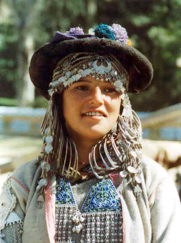
People & Tribes > Gaddis
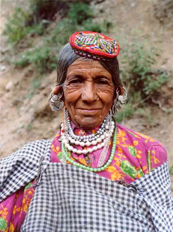
Gujjars
Malana
 GENESIS OF HIMACHAL
PRADESH GENESIS OF HIMACHAL
PRADESH
Himachal
Pradesh came into being as a part C State of Indian Union on 15th
April, 1948 by integrating 30 big and small hill
states.
These State were:
Baghat, Bhajji, Baghal, Bija, Balsen, Bushehar, Chamba, Darboti,
Deloth-Dhadi, Dhami, Ghund, Jubbal, Khaneti Kyarhoti, Kumarsain,
Kunnihar, Kuthar, Mandi, Madhan, Mahlog, Mangal, Kot (Ratesh),
Keonthal, Rawinigarh, Sangri, Sirmour Suhet, Tharoch, Theog etc.
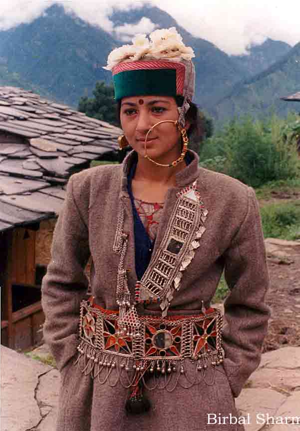
Image by Birbal Sharma
All these areas at theat
time constituted four districts namely: Chamba, Mahasu, Mandi and
Sirmour with a area of 27,169 square kilometers
In 1954, the neighboring
State of Bilaspur was integrated with Himachal Pradesh there by
adding one more district having 1167 S.K
HP remained
part C State of the Indian Union till 1956.
In 1956 States
reorganization Commission recommended to abolish the categorization
of States as Part A, B, C etc.
H.P. status as
Union
Territory continued till the conferment of Statehood on 25th
January, 1971. |
|
In 1960, the Border
chini tehsil of Mahasu district was carved out as a separate
administrative unit and district Kinnaur was formed raising
the total number of districts to rise. |
| |
 |
|
 |
On 1st November, 1966 the
then Pubjab State was reorganized with the formation of Haryana as a
separate State and Kullu, Kangra, Shimla and some hilly areas of
Hoshiarpur district and Dalhousie of Gurdaspur district merged into
HP and four new districts formed viz. Kullu, Lahaul-Spiti, Kangra
and Shimla.
With this addition at that
time, HP constituted of ten districts, an area of 55,673 kilometres
and population 28.12 lakh (1961 census).
On 1st
September, 1972 two more districts viz Hamirpur and Una were created
by trifurcation of Kangra districts.
Mahasu and Shimla
districts were recoganised as Shimla an Solan districts on 1st
September, 1972.
Since, 1st September, 1972
onwards, there had been no change in the administrative structure of
HP. Presently, there are 12
districts, 52 Sub-divisions, 75 tehsils and 34 Sub-tehsils in
Himachal Pradesh.
PHYSICAL
FEATURES
Himachal Pradesh is almost wholly mountainous with altitudes
ranging from 350 meters to 6,975 meters above the mean sea level. It
is located between Latitude 30O 22 40 N to 33O 12 20 N and Longitude
75O 45 55 E to 79O 04 20 E. It has a deeply dissected topography,
complex geological structure and a rich temperate flora in the
sub-tropical latitudes. Physiographic ally, the State can be divided
into five zones viz. (i) Wet Sub-temperate zone, (ii) Humid
Sub-temperate zone, (iii) Dry temperate-alpine High lands, (iv)
Humid Sb-tropical zone, and (v) Sub-Humid Sub-tropical zone. Wet
Sub-temperate sone comprises Palampur and Dharamsala of Kangra District, Jogindernagar
area of Mandi district and Dalhousie area of Chamba district, Humid
Sub-temperate zone comprises the districts of Kullu, Shimla, parts of Mandi,
Solan, chamba, Kangra and Sirmour,
Dry temperate-Alpine High lands include major parts of Lahaul-Spiti,
Pangi and Minnaur,
Humid Sub-tropical zone consists district Sirmaur, Bhattiyat valley
of district chamba,
Nalagarh area of district Solan, Dehragopipur and Nurpur areas of
district Kangra
and; Sub-humid tropical zone sirmaur and Indora area of district
Kangra.
Climatically Himachal
Pradesh can be divided into three zones (I) The outer Himalayas, (ii)
The Inner Himalayas and
(iii) Alpine zone. The first zone gets annual rainfall between 150
cms and 175 cms. In second it varies between 75 cms to 100 cms and
the Alpine zone remains under snow for about five to six months. The
average annual rainfall in the State is about 160 cms. The climate
varies between hot and a humid in the valley areas to freezing cold
in the home of perpetual snow.
The soils of Himachal
Pradesh can be divided into nine groups on the basis of their
development and physio-chemical properties. These groups are
alluvial soils, Brown hill soils, Brown earths, Brown porests soils,
Grey wooded or Podozolic soils, Grey brown podzolic soils, Plansolic
soils, Humus and iron Podzols and Alpine hunus mountain skeletal
soils.
Five perennial rivers Sutlej, Beas, Ravi,
Chenab and Yamuna flow
through its territory. The utility of these rivers though restricted
considerably by the rugged and undulating terrain of the State,
nevertheless, these rivers posses immense potential for the
generation of hydro-electricity.
|
| Area - |
55673 Sq. km |
| Total Population - |
60,77,900 |
| Males (Percentage)- |
50.80 |
| Females (Percentage)- |
49.19 |
| Decadal population Growth (1991-2001) -
|
17.53% |
| Population Density - |
109 |
| Sex Ratio - |
970 |
| Rural Population - |
54,82,319 |
| Urban Population - |
5,95,581 |
| Scheduled Caste Population - |
15,02,171 |
| Scheduled Tribe Population - |
2,44,587 |
| Literacy Rate - |
77.13% |
| Male Literacy - |
86.02% |
| Female Literacy - |
68.08% |
| Districts - |
12 |
| Sub-Division - |
52 |
| Tehsils - |
75 |
| Sub-Tehsils - |
34 |
| Developmental Block |
75 |
| Towns - |
57 |
| Panchayats - |
3,037 |
| Panchayat Smities - |
75 |
| Zila Parishad - |
12 |
| Urban Local Bodies - |
53 |
| Nagar Nigam - |
1 |
| Nagar Parishad - |
19 |
| Nagar Panchayats - |
33 |
| Census Villages - |
20,118 |
| Inhabited Villages - |
16,807 |
|
Health Institutions - |
3,831 |
| Educational Institutions - |
15,800 |
| Motorable Roads - |
23,788 Kms. |
| Villages Connected with Roads - |
8006 |
| Road density - |
42.10 Kms |
| Bridges - |
1169 |
| National Highways - |
8 |
| Identified Hydroelectric Potential
- |
20,376 MW in five rivers basins i.e.
(Yamuna, Satluj, Beas, Ravi & Chenab) |
| Potential harnessed |
3945MW |
| Irrigation facility available (CCA Created) -
|
1.95 lakh hectare |
| Food grain production - |
17.83 lakh tonnes |
| Vegetable production - |
7.00lakh tonnes |
| Area under Vegetable production -
|
38,000 hectare |
| Fruit Production - |
5.44 lakh tonnes |
| Milk Production - |
7.60 lakh tonnes |
| 10th Five Year Plan (2002-2007) -
|
Rs. 10750 Crore |
| Per Capita Income - |
Rs. 24,800 (Quick Estimate)
|
| |
|
Himachal Pradesh has been adjudged best
in the country in the field of education by the prestigious
weekly 'India Today' in its annual survey "States of the
States2005".
Read
more. |
| |
The stamp of
Himachal
S.P. Sharma
on the many colourful
stamps and first-day covers on Himachal Pradesh |
| |
| MEASURES
TO PROMOTE TOURISM IN HIMACHAL
Dr. Rakesh
Kapoor |
| The tourism policy should focus on two man made
lakes namely Pong and
Gobind Sagar, the former has already been declared a national
wet land and Ramsar site
for development of adventure tourism, water sports and
developing way side amusement parks and tourist villages to
attract large number of tourist ready to visit from
peripheral districts of Punjab and Union Territory of
Chandigarh on week ends and vacation. Read
More.. |
|
|